Abstract
| THE ICHETUCKNEE RIVER SYSTEM is one of three of the best known and most studied spring and river systems in Florida. The system begins in the Ocean Pond, Lake City and Raiford Ridges geomorphic provinces near Lake City and ends in the Branford Karst Plain geomorphic province. It crosses the Cody Escarpment from recharge areas to the north and the springs and river to the south.
Of interest within the system are (1) an area of minimal recharge, (2) poljes and swallets within the escarpment that contribute water to the drainage basin (springshed), (3) karst windows, (4) a karst trace, (5) glorious springs, and, finally, (6) the Ichetucknee River itself.
This paper describes these features and how they contribute to the springs and river within the Ichetucknee Springs State Park.
Topography and Hydrogeology
A springshed is the drainage basin that supplies water to a spring or spring group. As is the case with the Ichetucknee River system, a springshed may include areas where recharge to the aquifer that hosts the groundwater flow system and springs is minimal and well as areas where recharge is concentrated in karst features, and areas where it is dispersed.
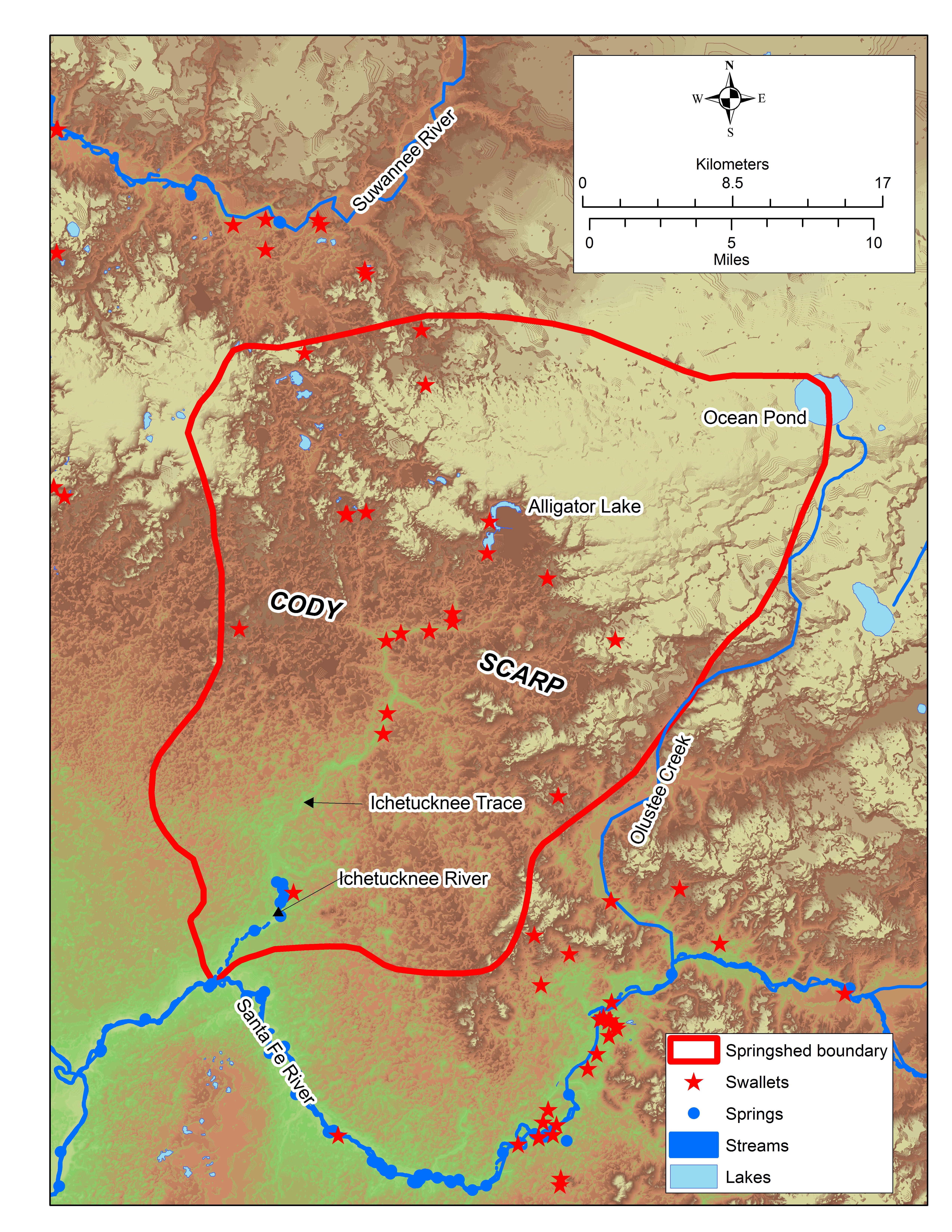
Figure 1 shows the Ichetucknee Springshed with the regional topography. The relatively high areas shown in a greenish yellow tint are within the recently named Ocean Pond, Lake City Ridge, and Raiford Ridges provinces of Williams et al. (2020). The Miocene Hawthorn Group of sediments underlies this area. Because of its clay content and the tortuous flow paths that recharging water must take to reach the Eocene Ocala Limestone below, the Hawthorn Group serves as an aquitard that limits recharge where it is thick. Even so, there is groundwater drainage in the Ocala Limestone that feeds the Ichetucknee River System.
The Cody Scarp (Puri and Vernon, 1954) is a fluviokarst escarpment (Upchurch, 2014) that represents headward erosion of the stream and sinkhole topography as the Hawthorn Group is removed. On Figure 1, the Cody Scarp is represented by the brown colors. Notice how “rough” the topography appears. This is because the escarpment is characterized by sinkholes and larger poljes surrounded by erosional remnants of the Hawthorn Group. The low areas in the scarp are at or near the top of the Eocene Ocala Limestone. As streams drain the highland areas, they encounter these karst features (swallets) and form a region of enhanced recharge. Only the largest rivers (i.e., the Suwannee River) cross the escarpment without going underground. The Cody Scarp is termed the Alachua Karst Hills province by Williams et al. (2020).
The green and greenish brown areas on Figure 1are part of the Branford Karst Plain province of Williams et al. (2020). This karst plain has little or no remnant Hawthorn Group sediments. Where present, they are residual clays that cap the low hills. A thin veneer of Plio-Pleistocene marine sand mantles the Ocala Limestone here. Because there is no aquitard and no streams in this area, it serves as a region of dispersed recharge to the limestone aquifer.
The Springshed
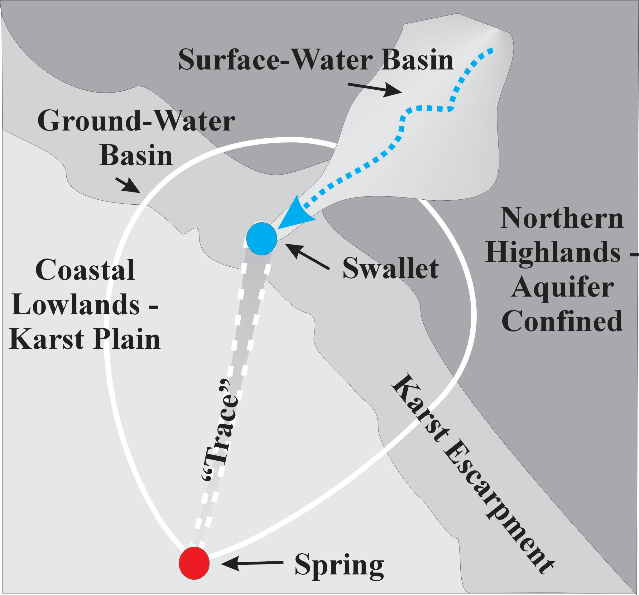
Figure 2 shows a hypothetical springshed based on the Ichetucknee River System (Scott et al., 2004). A springshed is a combination of all regions that contribute to the water discharging from a spring or spring group (Copeland, 2002). In systems like the Ichetucknee System, the springshed includes both a groundwater basin and surface water drainage basins. Streams drain the areas where the aquifer is confined, and recharge is limited. When they reach the escarpment, they recharge the aquifer through a swallet. Because groundwater drains the limestone aquifer under the confined area, the spring’s groundwater basin typically extends upgradient under the area of confinement. The limestone under the confined area has lower permeabilities than in the unconfined karst plain because of limited karst development so the potentiometric surface is typically higher than in the karst plain.
The groundwater basin part of the springshed for the Ichetucknee River System is shown in Figure 3. This map illustrates the potentiometric surface of the upper Floridan aquifer as determined by Upchurch and Champion (2003). If you compare Figures 1 and 3, it is evident that a significant part of the groundwater
basin extends under the uplands, where aquifer confinement is significant. For example, the Hawthorn Group and confinement begin near Alligator Lake in Lake City. However, the groundwater basin extends all the way northeast to Ocean Pond.
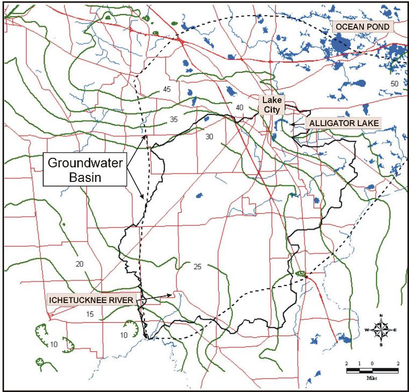
Notice also that the potentiometric surface is nearly flat northeast of the 45-foot contour, is steep from the 45- to the 30-foot contour and is again nearly flat southwest of the 30-foot contour. This pattern indicates where recharge is occurring. Under the highlands, recharge is minimal, and the relatively low permeability of the Ocala Limestone retards drainage to the southwest and results in a potentiometric surface high. The area of rapid change of the potentiometric surface is where permeability is elevated, and recharge is enhanced. This area coincides with the Cody Scarp. Where the surface flattens out to the southwest, permeability of the limestone aquifer is relatively high, and recharge is dispersed through the many sinkholes in the area.
Part of the reason that the reentrant of the potentiometric surface extends as far northeast as Ocean Pond is groundwater use in the Lake City area. However, the sinkholes and other karst features in the area are also well developed. The extent of the springshed is sensitive to recharge and water use. It expands and contracts as rainfall patterns and consumptive use vary.
Sinkhole Lakes, Poljes and Swallets
Streams that originate in the highlands flow toward the Cody Scarp, largely because the Hawthorn Group of sediments prevents significant recharge of the underlying upper Floridan aquifer. However, when these streams reach the Cody Scarp, they flow into swallets, poljes, and sinkhole lakes. Swallets are sinkholes that capture streams. Sinkhole lakes are sinkholes that intersect the surficial or upper Floridan aquifer and are water filled. Poljes are large sinkholes that are filled with lake or wetland sediments. All three are present in the Cody Scarp.
Swallets
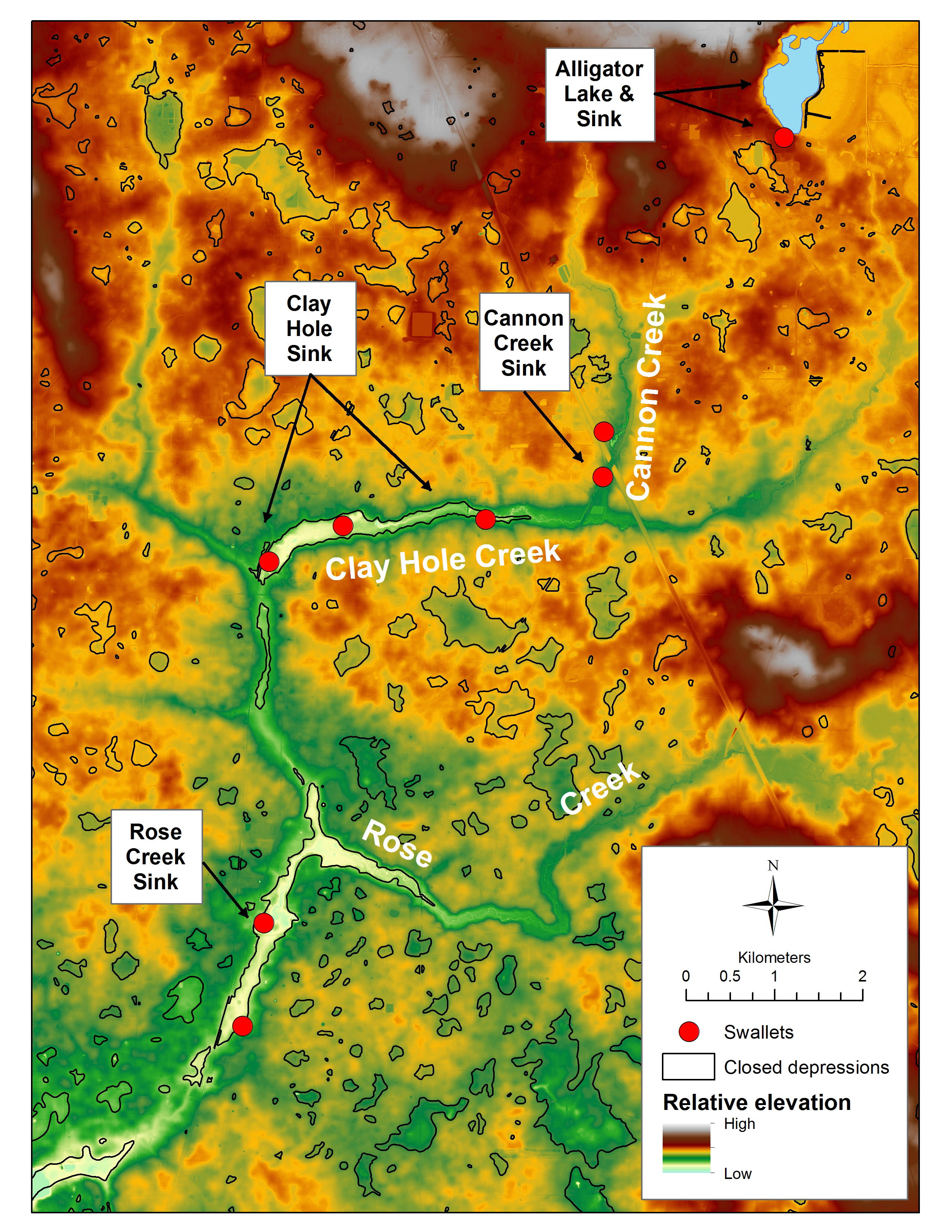
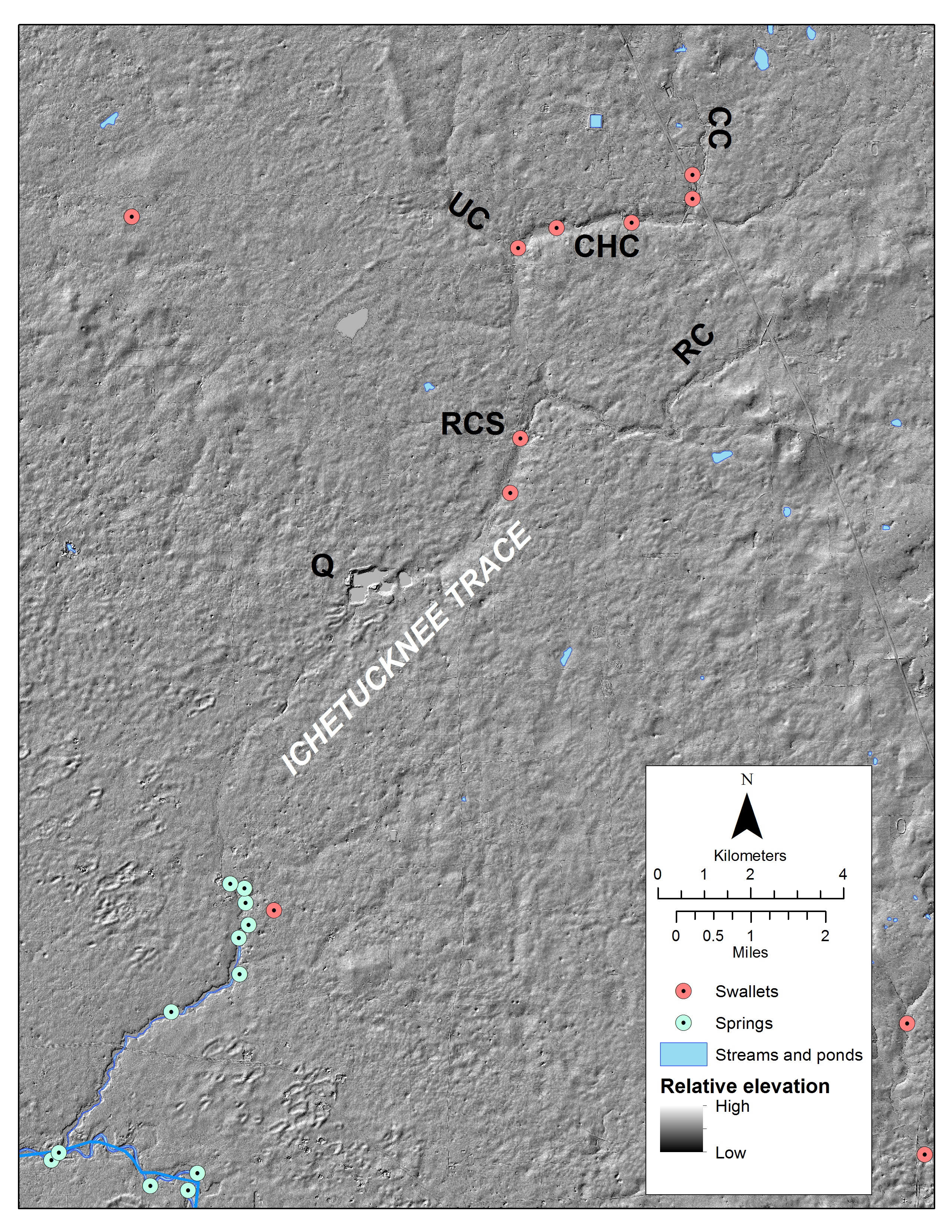
Figure 1 shows the locations of known swallets in the Ichetucknee Springshed. Note that all the known swallets are within the brown elevations that reflect the Cody Escarpment. Let’s look at two of the best-known swallets – Cannon Creek Sink and Rose Creek Sink (Figure 4).
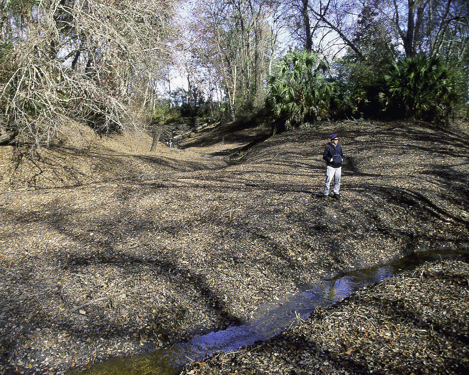
Cannon Creek drains the Alligator Lake area on the eastern side of Lake City. It includes an overflow channel for the lake and discharges into a pair of swallets that are adjacent to I-75 and State Route (SR) 47. Normally, the creek goes underground in the swallets (Figure 5). When the stream flow exceeds the infiltration capacity of the swallets, stream flow continues to Clay Hole Sink (Figure 4) and then to flooding the dry stream valley downgradient.
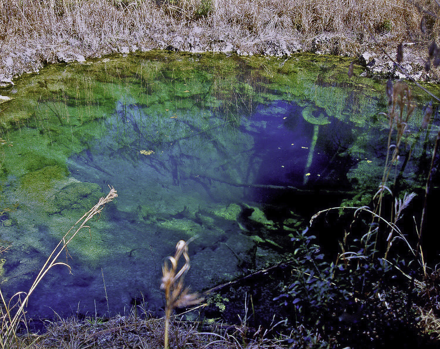
The Rose Creek Swallet is in the Community of Columbia in the northeast corner of the intersection of SR 47 and County Road (CR) 240. There are two swallets in this location. The upstream swallet captures water from Rose Creek under normal circumstances and the downstream one is a karst window exposing upper Floridan aquifer water in a sinkhole (Figure 6). During floods, water enters the aquifer via both sinkholes and then flows into the dry stream channel that connects to the Ichetucknee River.
Sinkhole Lakes
There are many small to medium sized, water filled sinkholes within the Cody Scarp (Figure 1). These are sinkholes that intersect the upper Floridan aquifer and are normally filled with water.
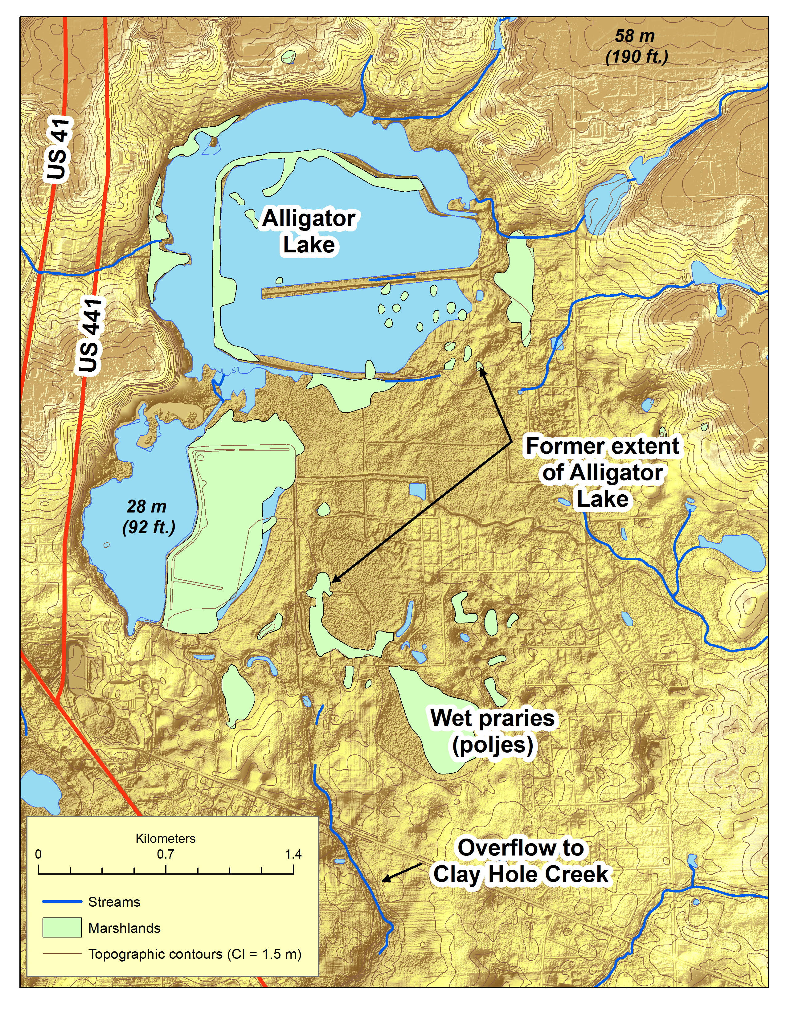
Alligator Lake (Figure 7) is an example that is famous for draining every 10 years or so. The sinkhole through which the lake drained is located on the southwestern shore of the lake. When Lawrence and Upchurch (1982) were investigating groundwater quality in the area, Alligator Lake drained and homeowners with wells downgradient to the southwest experienced discolored water, silt, and fish bones and leaf fragments in their water. Today, the lake has been heavily diked, and drainage is not as great a problem. When lake levels were high, the lake drained to Clay Hole Creek which was captured by the Clay Hole Sink (Figure 4).
Poljes
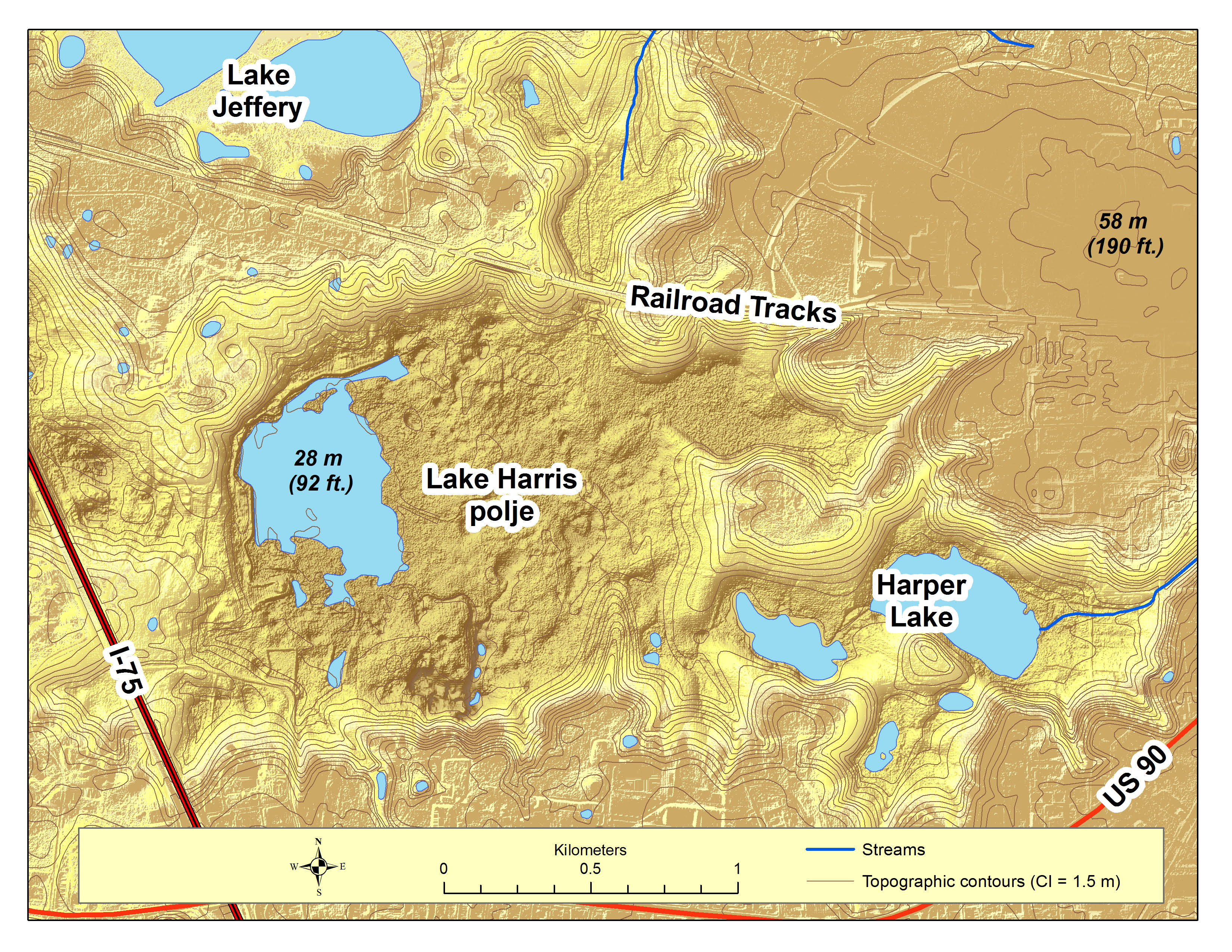
The most dramatic natural polje in the Ichetucknee Springshed is Harris Lake (Figure 8). This lake is mostly dry or wetlands today. It is located on the southwestern side of Lake City and has short gully and stream channels that carry stormwater away from the city.
The Importance of Poljes
There has been a lot of concern and money spent to reduce the contamination potential of groundwater flowing to the Ichetucknee springs. The poljes are a forgotten source of water, and potential contamination, to the springs.
Back in the early 1980s, Lawrence and Upchurch collected a lot of groundwater quality data that was not presented in their 1982 paper. Upchurch reworked the data for the Karst Systems of Florida (Upchurch et al., 2019) demonstrated this importance by mapping the distribution of the concentrations of phosphorus, as orthophosphate, in groundwater around Lake City (Figure 9).
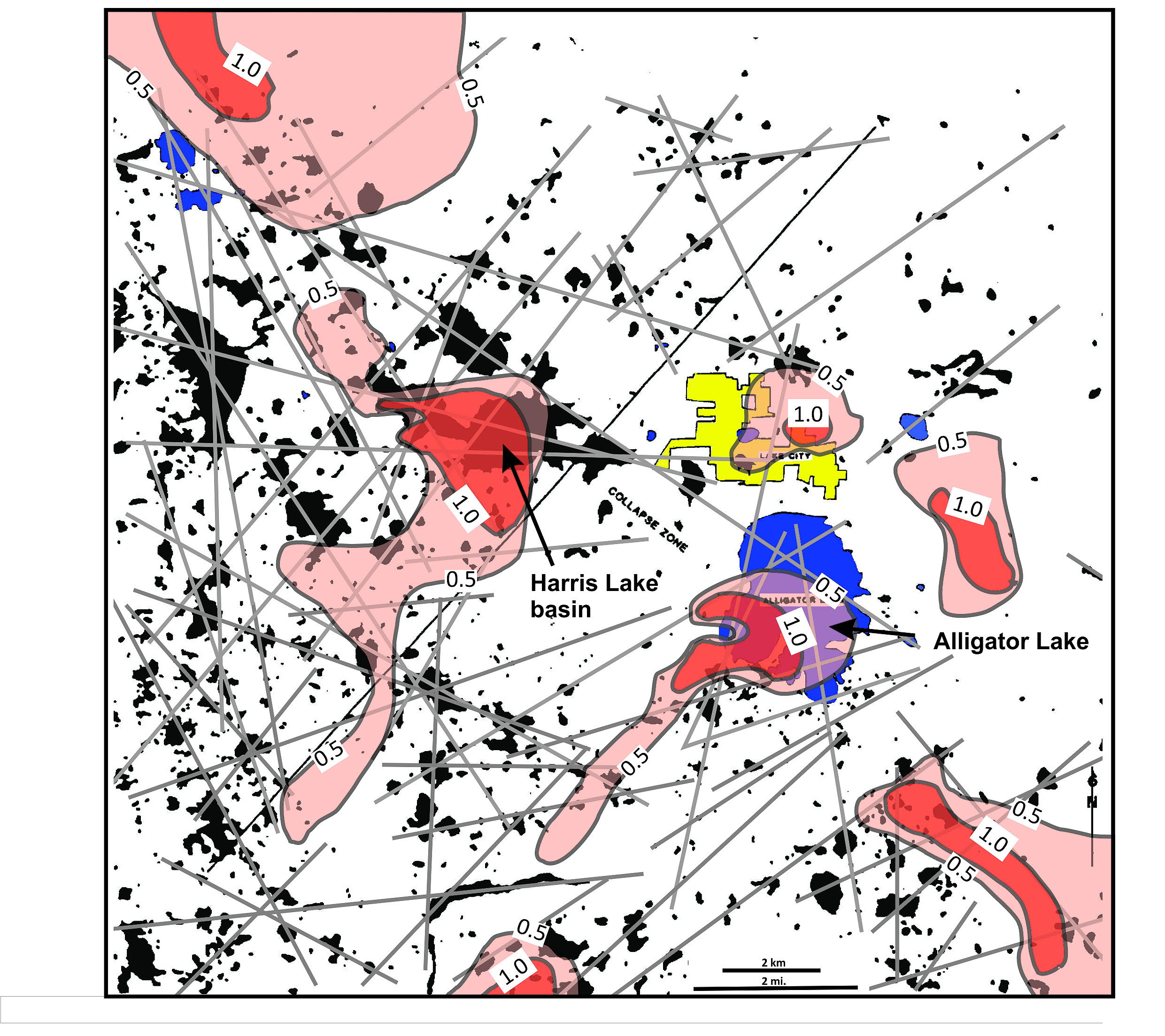
The phosphate originates as natural weathering products and fertilizers and is sensitive to the alkalinity of water. Alkaline water, which contains dissolved bicarbonate, interacts with orthophosphate, and causes a variety of the mineral apatite to precipitate. This is the mechanism by which hard-rock phosphate, which was once mined in the state park, formed.
With respect to the poljes, plumes of phosphate-rich water were found to be emanating from the Lake Harris polje and Alligator Lake as groundwater plumes that appear to follow the patterns of fractures (photolinear features). While the phosphate concentrations decline because of dilution and precipitation of phosphate minerals, other constituents, such as nitrate, persist and contribute to the movement of human-induced constituents to the Ichetucknee springs.
Karst Traces
These karst landforms in the Lake City area are evidence of the retreat of the Cody Escarpment to the north and east by headward erosion. The streams cut through the clay-rich sediments of the Hawthorn Group until they encounter limestone. When the slightly acidic stream water meets the limestone, a sinkhole/swallet ultimately develops. Capturing of stream flow by the new swallet causes the stream channel downstream from the swallet to be abandoned. The stream valley remains but it only carries water during extreme rainfall events when the infiltration capacity of the new swallet is exceeded. Over hundreds of thousands to millions of years, this process creates a long-abandoned stream channel with swallets and karst windows along its path.
In the 1980s, biologist and springs advocate Jim Stevenson saw the normally dry channel that begins at the head of the Ichetucknee River and its springs and extends north and east to Lake City. He began calling this dramatic feature the “Ichetucknee Trace.” That term stuck and was defined internationally by Upchurch et al. (2019).
Figure 10 is a LiDAR (Light Detection and Ranging) map showing the topographic expression of the trace and river. Note that, as headward erosion cuts into the Cody Scarp, the abandoned stream channel becomes more distinctive.
Where Does the Water Go?
When water enters the limestone aquifer by way of sinkholes, swallets, sinkhole lakes, and poljes it creates karst conduits and cave systems. It has long been obvious that the Ichetucknee Springs drain water that recharges the aquifer to the north and east, but evidence of the subterranean drainage system did not exist until the cave-diving and research community because involved. Cave divers have explored segments of the cave system, but the big breakthrough came with dye tracing (Karst Environmental Services, 1997; Butt and Murphy, 2003). These and other studies have clearly connected the upper Floridan aquifer recharge areas near Lake City with the springs on the Ichetucknee River. These dye traces also resulted and amazing revelation – water and its chemical constituents were found to travel at velocities as great as a mile per day. This rate of groundwater movement indicates that the cave system that carries water from the Lake City area to the springs is well developed and that it can carry water with minimal dilution and dispersion over unexpected distances.
The Springs
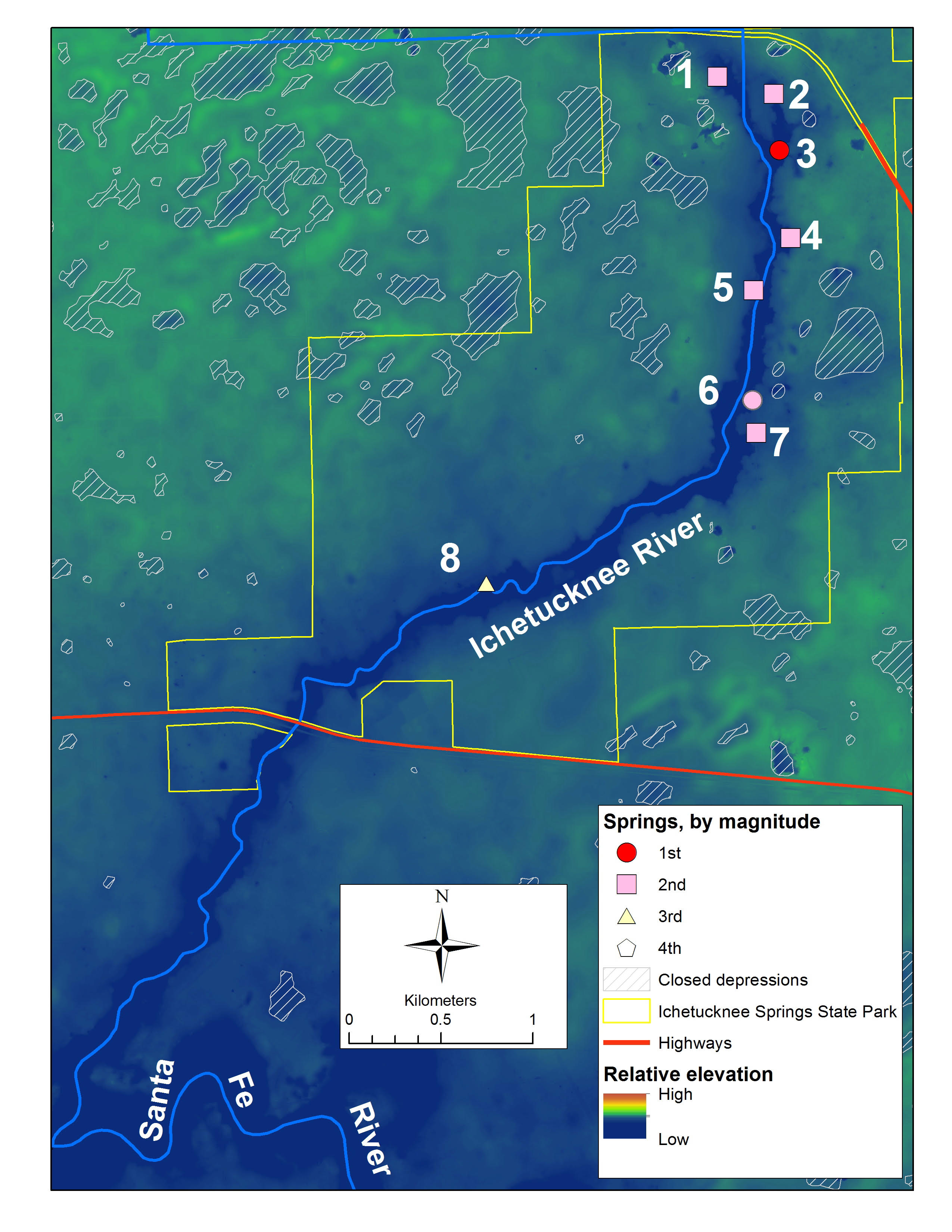
The groundwater accumulates within the springshed and ultimately comes to the surface at the springs within the Ichetucknee Springs State Park. The only exception to this is Coffee Spring (Figure 11), which appears to represent a shallower drainage system.
The Ichetucknee springs make up a “spring group” (Copeland, 2003). Most of the springs are historic second (average flow between 10 and 100 cubic feet per second [cfs]) and third (1 to 10 cfs) magnitude. Only Blue Spring is considered a first magnitude (discharge greater than 100 cfs) spring. Coffee Spring is a low third magnitude spring. Collectively, the spring group is treated as a first magnitude spring system.
Conclusions
The Ichetucknee River system is one of the best-known karst systems. Surface water enters the groundwater system by way of swallets and poljes within the Cody Escarpment. This groundwater discharges through seven springs of the Ichetucknee Spring Group.
References Cited
Butt, P.L., and G. J. Murphy, 2003. Dyal and Black Sinks Dye Trace, Columbia County, Florida, May-September, 2003. Contract report prepared by Karst Environmental Services, Inc., for the Florida Department of Environmental Protection, Florida Springs Task Force, 132 p. [Publication available at http://www.dep.state.fl.us/springs/reports/index.htm]
Copeland, R. (Compiler), 2003. Florida Spring Classification System and Spring Glossary. Florida Geological Survey, Special Publication No. 52, 17 p.
Karst Environmental Services, 1997. Ichetucknee Springs Water Quality Working Group Cooperative Dye Trace: Rose Creek Swallet-Ichetucknee Springs Group. Report produced for the Ichetucknee Springs Working Group and the Suwannee River Water Management County.
Lawrence, F.W., and S.B. Upchurch, 1982. Identification of recharge areas using geochemical factor analysis. Ground Water, 20:680-687.
Puri, H.S., and R.O. Vernon, 1964. Summary of the Geology of Florida and a Guidebook to the Classic exposures. Florida Geological Survey Special Publication 5 (revised), 312 p.
Scott, T.M., G.H. Means, R.P. Meegan, R.C. Means, S.B. Upchurch, R.E. Copeland, J. Jones, T. Roberts, and A. Willet, 2004. Springs of Florida. Florida Geological Survey, Bulletin No. 66, 377 p. plus CD ROM.
Upchurch, S.B., 2014. An Introduction to the Cody Escarpment, North-Central Florida. In A. Lawn (Compiler), Karst Hydrogeology of the Upper Suwannee River Basin, Alapaha River Area, Hamilton County, Florida. Tallahassee, Southeastern Geological Society, Field Trip Guidebook 63, pp. 13-28.
Upchurch, S.B., and K.M. Champion, 2003. Geostatistical Analysis of Water-Level and Water-Quality Data for the Ichetucknee Springshed. Live Oak, Florida, Suwannee River Water Management District, __ p.
Upchurch, S.B., T.M. Scott, M.C. Alfieri, B. Fratesi, and T.L. Dobecki, 2018. The Karst Systems of Florida: Understanding Karst in a Geologically Young Terrain. New York, Springer Nature, 450 p.
Williams, C.P., T.M. Scott, an S.B. Upchurch, 2020. Florida Geomorphology Atlas. Florida Geological Survey, Special Publication 59, available at https://floridadep.gov/fgs.